http://www.jean.cuisenier.free.fr Odysseus' navigations Europe as culture French country houses bibliography, biography
ODYSSEUS'
NAVIGATIONS
  A NEW EXPEDITION :
(texte français: cliquez ici)   In Odysseus'wake. Arrival at Ithaka.


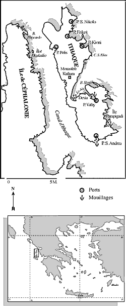
Coming from Corfu the crew of a sailing boat have difficulty discerning Ithaka among the numerous islands of the Ionian Archipelago.
THE PROJECT
A NEW EXPEDITION
THE 1999' EXPEDITION
THE 2000' EXPEDITION
Odysseus' nautical world
A cosmological interpretation
Sea routes and the epic text
The routes home
Rounding Cape Malea
6 Toward a New World
7 Mythological figures for stopovers
From the next World to this world
9 In Odysseus'wake. Arrival at Ithaka
10 Ithaka, Ormos Polis
Ithaka, the islet of Daskalio
12 Ithaka, Port Saint Andrew
13 At the Arethuse source
14 The periplus to Ithaka
15 Our friend Odysseus
Ithaka is a double island, Homer says, rocky and montainous, clearly visible from far, with numerous harbours and anchorage places.
 
"If Corfu is really the Phaeacians' island, we must indeed try to land on Ithaka in the morning, a short time after sunrise, so as to conform to the text of the Odyssey. Homer reports that Odysseus sailed for Ithaka on the stern of a ship ordered by the Pheacians' king to carry him to the dazzling setting sun" (Od., XIII, 28-30, C) and that "just when the shining star rises and announces that Eos, the daughter of the morning, gets up, then the deep sea ship came near Ithaka and reached land" (Od., XIII, 93-95, C). So, the hero took only one night to do the crossing on a ship built for race" and "the sparrow-hawk itself, the fastest of the birds, could not have beaten him" (Od. XIII, 86-87, B). In Odysseus'wake we took only one night, like him, with our fast catamaran to cover the same distance of 85 nautical miles.
On that morning of September the gods fulfill our wishes. The sun is glorious, the visibility excellent, the sea covered with small white horses formed by the rising wind after the calm of the night. From very far we can see the island, the white Cape Doukaton that marks the very southern end of Levcas, the well-named. The islands are distinguished themselves from one another. Clearly, an archipelago comes into view…
How to succeed in sailing through this indistinct mass if, like Greek sailors, we had no binoculars, no charts to help us to decipher the indentations of the coast ? Through which channels to pass, through which passes to go to avoid gusts of wind ? Which harbour I would choose, I wondered, with all modern navigation helps I have at my disposal ? Shall I go west through Steno Ithakis, the channel separating Ithaka from Cephalonia ? Or east through the Ionian Sea ? Because I want to get the nearest possible to the coast to see its details better. But with this force 5-6 north-east wind on the Beaufort scale, the Zephyros of ancient Greeks, there is a risk of being driven against the cliffs when going west. And the nautical instructions report that the coast falls sheer into the sea without underwater rocks bordering it. So, with our catamaran we shall be able to sail very near along it.
It is decided : we shall discover Ithaka from the north-east." next
   
Jean Cuisenier, Le Périple d'Ulysse, pp. 24-25


Texts and pictures are protected by copyright. Please send me a mail by clicking on the left icon for permission to reproduce any of them for any other purposes than private use.
NB: Please d on't be surprised if I don't answer you immediately, since I am frequently working in the field or on nautical expedition.